Get a Quote
Fill in your project details and see your estimated price update in real time.
Your Details
Select Services
Project Details
Additional Info
We'll confirm your quote within a few hours.
50% deposit to start · 50% on delivery · Crypto · PayPal · Wire · Cash
Quote Sent!
We've received your project details.
Check your email for a copy of this quote.
We'll follow up via WhatsApp and email shortly.
Chat on WhatsApp
Your Instant Estimate
Select services and enter your project size to see your price estimate instantly.
Payment MethodsCrypto · PayPal · Bank Wire · Cash
Based inSan José, Costa Rica — serving all regions
Getting Started Is Easy
From request to delivery in three simple steps — no technical knowledge required.

Request a Quote
Takes 5 minutes. Fill out our online form with your location and project size — we'll email you a free estimate immediately.
Select Date & Sign Contract
Once the quote is agreed, pick a date. We send a contract and invoice — 50% deposit on signature confirms your booking.
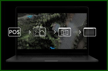
Mission Execution & Delivery
We fly, process the data, and deliver your maps and reports in 3–7 business days via Google Drive.
Common Questions
How much does a drone survey cost in Costa Rica?
Our drone surveys start at $1,000 USD for up to 5 hectares, including the full flight mission, GPS base station, data processing, and all deliverables. Each additional hectare beyond 5 is $80 USD.
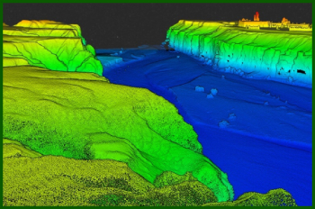
What is the difference between Lidar and photogrammetry?
Lidar uses laser pulses to measure distances and can penetrate dense vegetation to map the ground surface below. Photogrammetry uses overlapping aerial photos to create 3D models and is more cost-effective for open terrain.
How accurate is a drone survey in Costa Rica?
Our drone surveys using the DJI Zenmuse L1 Lidar system achieve centimeter-level accuracy (typically 1–3 cm horizontal, 2–5 cm vertical).
How long does a drone survey take in Costa Rica?
Field data collection for most properties takes 2–8 hours depending on size and terrain. Data processing and delivery typically takes 3–7 business days.
Do you survey all areas of Costa Rica?
Yes, we survey all regions of Costa Rica including San José, Guanacaste, the Central Valley, Caribbean coast, Southern Zone, and remote areas.
What file formats do you deliver?
Deliverables include .dwg, .dxf, .shp, GeoTIFF orthomosaics, LAS/LAZ point clouds, AutoCAD-compatible files, and RINEX data — all on Google Drive. A 6-month 3D cloud visualizer is included with every LiDAR project.
Prefer to Talk First?
We have 7+ years of experience and 25 five-star reviews. Ask us anything before you commit.